Summer Guide - Our top Enduro MTB rides in the Val d'Anniviers
- John
- Jun 22, 2023
- 5 min read
With the summer season officially kicking off this weekend with the Rock The Besso Enduro race, now seems the perfect time to present the first of our Summer Guides: our top Enduro rides in the area! There is loads to choose from in the valley - more than enough to keep an avid rider busy! - but for accessibility, views and thrills, these are our favourites.
1. The Moiry Dam

Climbing 200m | Descent 1300m | Intermediate | 10km |
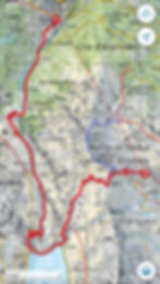
Easy to session, big mountain views, gnarly descent. This one is a cracker!
Start in Grimentz and jump on the Espace Weisshorn gondola up to the top of Sorebois, a near 3000 metre peak bang in the middle of the valley. From the top you have a short, steep kick up to the Col de Sorebois at 2837m which will probably require the odd bit of hike-a-bike effort to get to the top.

After that, its 1300m of pure downhill joy. From the col there are a number of bermed switchbacks to navigate down to the Lac de Moiry. Ensure you take the newly created trail for mountain bikers and not the hiking footpath here - its much more enjoyable. The first few turns are slightly exposed so take it slow before you find your rhythm; after this the line straightens out across the alpage (watch out for the cows!) and the views expand to take in the turquoise waters of the lake below.

Cross the dam and join the Grand Raid MTB marathon route down a few more switchback turns and underneath the dam. The route is signposted at the bottom and runs down to the stream below. Once over the stream, the trail leads up to an excellent rock garden section before joining back onto the road briefly at the bus stop.
From the road, the trail leads off to the right and down a wide, rocky track with a number of switchbacks before crossing back over the stream and down a long, straight and fast line through the woods and into Grimentz at the bottom.
TIP - This route can easily be looped or combined with our next top run below.
2. Sorebois - Ayer

Climbing 200m | Descent 1500m | Challenging | 12km |

If steep, big mountain shredding is your thing, this is one for you. Be prepared for hand cramps because the descent is a long one!
You can start in Grimentz or Zinal to get the lift up to the Espace Weisshorn area. The route begins with a warm up through some gentle dusty berms from the top of Sorebois down to the mid-station.

From the mid-station there is a gentle traverse/climb on an access track around to the north side of Sorebois. Along this traverse there are two options: the first is to come off early and ride the man-made avalanche barrier/ridgeline to the trail head (the wavy line pictured on the left), or secondly, carry on the access track a bit further up and ride the shorter but steeper natural ridge line to the trail head (pictured on the right with the rider at the top of the line).

After the “ridges", follow the trail around the traverse and drop down into the Tsirouc alpage (again watch out for the odd cow), passing a few huts on the left and admiring the direct views across the Val d’Anniviers. The trail then drops steeply through a series of rock garden features and tight switchbacks before hitting the treeline.
Once under the canopy, the trail gets gnarly. Steep is the name of the game and it is relentless. There are a few turns on the way but the route pretty much descends straight down the mountain, through rocks, roots and adrenalin-fuelled riding.
Just before the road, the trail splits. Continue left for Grimentz or right for a traverse around to Ayer. For Ayer, the trail gently undulates around the Ancient Bisse de Morasse for 1km before taking a tight left down across the road and immediately right again once onto the trail on the other side.
Continue through the woods on a rooted traverse before coming to a fire road, the trail resumes 100m on, crosses a small alpage before dropping steeply again through some more rock gardens (and switchbacks) and down to the river. Ayer is over the other side.
TIP - Have a spare set of brake pads with you. Just in case.
3. The Balcony Trail

Climbing 450m | Descent 1200m | Intermediate | 14km |

This is one for the views. One short climb for the starter, a spectacular traverse for the main, and a sweet descent for dessert.

Starting from the top of the Tignousa funicular railway in St Luc, continue on the Sierre-Zinal route past the observatory and across to Chalet Blanc at the foot of the Toûno mountain. From here its a climb up the gravel track to the Hotel Weisshorn, a perfect spot for refreshment before you hit the good stuff.

From the old hotel, the track narrows into single track and ascends a little more before skirting under the Pointes de Nava on a undulating trail with spectacular views. Continue on the same trail to the top of the Nava Alpage at 2400m on the map. There will be a signpost pointing to Ayer with a little stream running underneath the path.
Follow the grassy hairpin trail into the alpage until it hits a tarmac road at 2201m. Using the road, traverse around towards Barneuza where the tarmac will transition to track again before coming across a small crossroad and another signpost on the right marking the start of the narrow single track down to Ayer. Here the trail starts on a soft needle-strewn base but progressively steepens onto more challenging rocky terrain through the forest. Enjoy!
TIP - Have all day? Hit the bike park in the morning for a few runs and then continue on this route back to the chalet in the afternoon. Perfect!
Additional info
Navigation - We always recommend taking a map if you are unsure of the area but to help with navigation you can use the free app, Swisstopo, which provides detailed maps of the local area in Switzerland, just like the ones we have included in this post.
Lift pass - Day passes can be purchased from all of the lift stations in the Val d'Anniviers. There is a 50% reduction for all Anniviers Liberté holders (included with your stay at La Bergère!)
Buses - All Postbuses in the Val d'Anniviers are fitted with bike racks for getting around the valley. The Postbus is free for Anniviers Liberté holders but there is a charge for use of the bike rack.
Disclaimer
This post is not meant to be used as a definitive or exclusive source of information. Anyone undertaking the runs listed on this post is solely responsible for his or her own safety, and should exercise good mountain judgment, undertake thorough route research, be physically and mentally ready for the challenges, properly equipped and should be prepared to turn back if conditions become more challenging.